Sunday, November 23, 2014

A visit down memory lane in Punggol

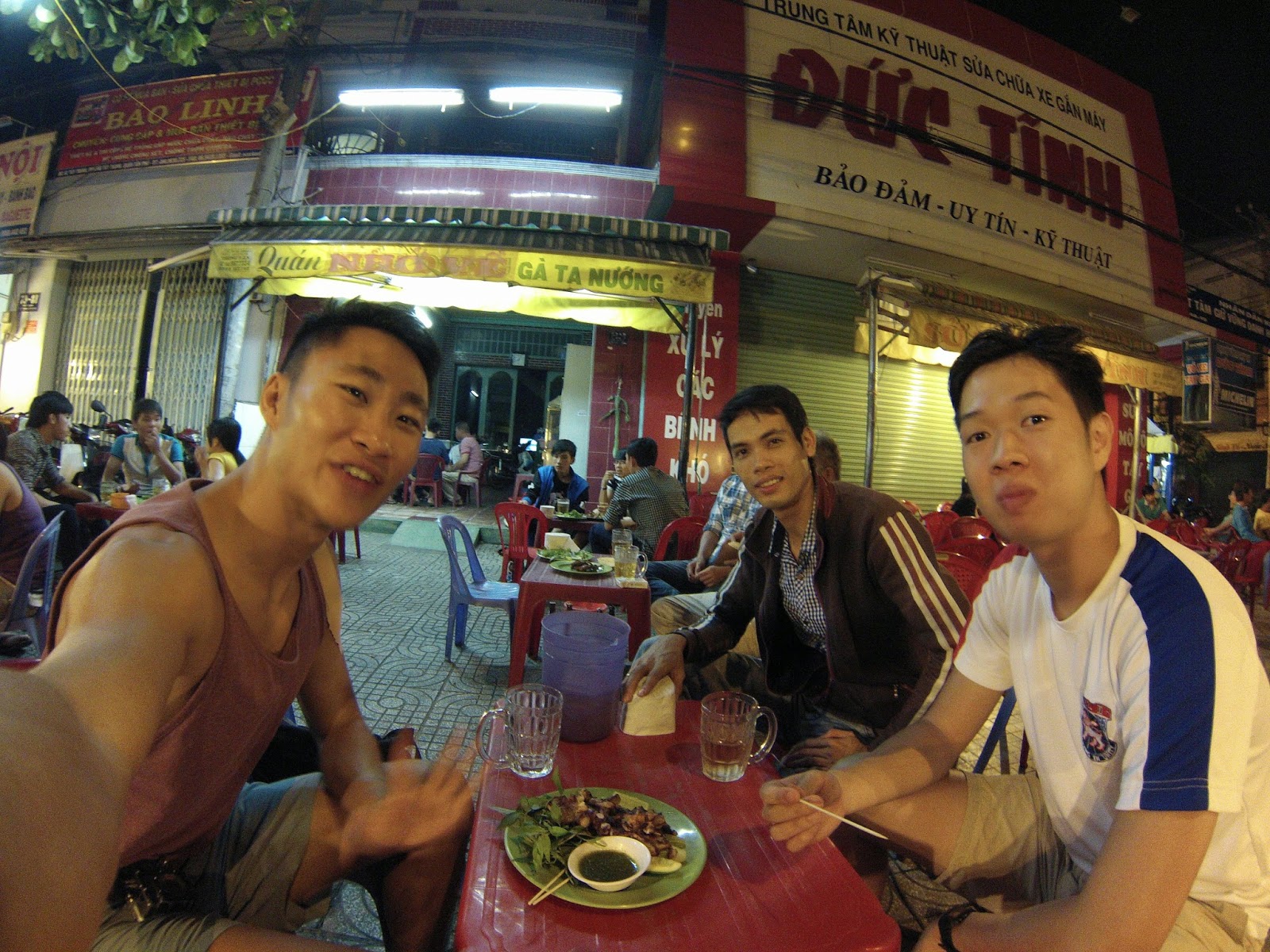
So the Salomon X-Trail was held at Punggol on 22nd Nov 14. It featured 'trail' running through the punggol waterfront (wouldn't consider running on the dirt path next to the road a trail run). The route showcased the transformation of the Punggol waterfront, from what it used to be, a swampland to a developed heartland with a scenic view filled with various integrated parks, developed waterfront and amenities.

After the Salomon X-Trail 2014 run

Back then, this part of Punggol was a little known secret for photographers, people who loved fishing as well the more adventurous ones who were looking for bits of unknown Singapore to explore. I remember hopping onto one of those fiddle bus routes, armed with a sketchy map which i got off one of the photography forums and headed for some of the marked sites, not knowing how the terrain would be like and was treated to a visual surprise to how such a quaint location existed in Singapore, a place that remained 'wild' that has not been transformed into a nice little nature park with proper polished walkways and stuff like that. It was like wanderlust in my own country, taking the evening off to just wander round these places, not knowing where i might end up nor find along the way. Each moment there was an adventure in its own right, from bashing the thick jungle, trotting across the dry lalang fields or walking through the big monsoon drains, seeing where it would lead me to. Also back then, there were no smart phones with GPS to guide me along and navigation was based on a sketch maps and the tall HDB landmarks to guide me back to civilisation for there were no road lamps to mark those areas.

As i ran through the route, it felt as though this place transformed into something which I was no longer familiar to, a place i used to wander around armed with Nikon D80, aimed at capturing some parts of the 'wild' punggol which i knew would disappear in time to come. And that time came 5 years later. Now, 7 years later, the places in this album has become nothing but a memory of Singapore's past, leaving us, poor city folks 1 less natural destination to get away from the bustling and stressful city life. Though I wish that these places remain untouched in this little island, I know that reality of this small city state is that it has to grow to flourish. Wished i had taken more time to go about photographing this transformation before it disappeared. Now these empty vast grassland has become nothing but a distant memory, replaced by developed spaces with high rise buildings, park connectors and eateries. But i guess this large plot of reclaimed land has to developed eventually after it is settled.

After witnessing the transformation while running through the 10km race route that used be an isolated stretch of land, I had an immense urge to dig out my old archives and share what i saw in 2007. Here's a glimpse of what Punggol used to be, and the things that I'll miss about it.

Cornie Island (left) can be seen while walking through this dirt path, now made into a clean cycling and walking road with benches and shelters along the way

Hideaway for people to come and get out of the bustling city life

 Large open fields of nothingness

 My Fav lalang fields

 Relaxing walk out by the tranquil waterway

Reclaimed land waiting to be developed

Pristine Lalang fields

 Songs of nature as birds and small animals flock round the area

 Matilda house (then), now surrounded by high rise buildings

And of course lots of vegetation that makes a good trek in

Gone fishing: What Punggol End used to look like with its old school pier and police outpost

Pictures taken 2007, Nikon D80, Tamron 16-50 f2.8/ Tokina 12-24 f4


Tuesday, November 18, 2014

HCMC revisited!

So I was back to Ho Chi Minh City after 18 months and I would think that it would be a rather fulfilling trip! Rented a bike and off we went!


Vietnam would be incomplete without biking through its 'crazy' traffic

Damn i want this bike

 Met up with old friends and visited their local haunts!

With Thiem having bbq octopus!


Some bbq scallops!

And of course trung vit lon!

It was a great weekend getaway! Got to visit some of the old favourites as well as the really good places which I missed the previous time as i had to teleport to Hanoi for the rest of my internship.

Here’s what I enjoyed the most! Besides just chilling and uong tra da!

People watching while sipping their refreshing ice tea!

Brunch
70 Le Loi - L’usine

Nothing bad to say about this place except that it has been pretty successful and have opened another brunch down the road from the one i visited the last time. Ambience is pretty hipsterish boutique downstairs as well as good western style brunch menu upstairs.


Local
260C Pasteur - Pho Hoa

And what would a visit to Vietnam be without trying their signature local dish - Pho Bo (Beef noodles). This shop is said to have one of the best phos in HCMC and it didn’t disappoint. Although, a little pricey, it sure made it up with its generous serving and mouth watering flavours. Different taste from the Pho Thin (The “best” pho in Hanoi) but it sure makes it the best pho i’ve tasted. A definite must go when i return there. 

Frenchie
74 Hai Ba Trung - The Refinery

HCMC, a city with lots of french influence in the past definitely has its own flair of French cuisine and the refinery is not to be missed! Dinner with wine here is a fantastic way to to end the day. 

Seafood
94 Dinh Tien Hoang - 94 Crab

A place i missed the previous time due to severe food poisoning. A place that you can’t miss! Its such a unique dish! Crab meat (not crab sticks) served with vermicelli noodles! Can be a little expensive though. Spent almost all our money there, doubting whether we would have enough for the cab there!


And am honorary mention to
158 Pasteur - Secret Garden

A really secret garden indeed! Located on top of a small building, it has a really nice quaint compound that serves local food

With Willis and Giang for lunch!


 Banh Xeo


Bun Bo


Thursday, September 4, 2014

The journey back

Having reached the summit just before the Monsoon didn't spare us the effects of the monsoon the following days. We finally left Kothe (3400m) after a day's rain and like you guessed it, under rainly conditions. My estimate was that it had been raining continuously since the day we left Khare.

The route to Chetarwa (4600m) consisted a terrain similar to the wet scottish highlands and of course that crazy rocky upslopes and what greeted us were tons of water falls flowing through these routes with them being the only natural pathways for the rain water to flow off the mountains. Though really wet, it was kinda a different experience despite the really irritating rain which caused me to not take much photos. It was like from hopping from stone to stone trying to avoid the streams to just giving up and walking in the water.

With the monsoon moving into the mountain range, sounds of avalanches could be heard in the distant while navigating the high passes and the feeling or relieve that we weren't any were near those places could be felt.

I must say, the weather always sculpted a whole new set of terrain even though it was the same route that we took on the way to the summit. Crossing the high pass that looked so similar to the high pass, the same one where enroute to Kothe a week earlier, was filled with the smell of rosemary was totally different with the slight rain and fog, making it difficult to spot our porter (who amazingly carried 2 of our bags because raj had to leave for another trekking job) who set out front to mark the route as well as to keep track of mr namaste who was quite behind me and whom i didn't want to get lost out there (due to his track record).

Finally, at around 3pm, the small village of Chertawa emerged through the fog and boy was i glad to see it for the growling had started to grow in my stomach for some hot garlic soup. But when upon reaching the village, i was shocked to hear that we might be pushing down to Chutang that day. But that night, we stood round the heater and just chilled, drying our wet socks and shoes at the same time.


Passing through one of the new waterfalls


 Walking pass the many new streams made by the monsoon in the mountains


Avalanches could be heard in the distant mountains

Someone made a welcome sign for us out of flower petals!

 Totally giving up on trying to avoid the streams

  Frost on his eyebrows as we headed higher in altitude

  Trying to keep sight of the porter

  Really amazing scenery as the clouds roll across it.

 Sighting Chertawa from afar

  As KY passes the finally ridge before making it to the base of the village

 Night sky in Chertawa


Being the last hikers of the season was quite special. The tea houses we passed were mostly packed and ready to evacuate for the monsoon season, waiting for us to pass before packing up completely and heading to Lukla or another village. It was quite funny because the girl that was incharge of the Thangnag tea house followed us to Chertawa and then onto to Lukla followed by Kathmandu. I was always quite shocked when she appeared in the town where we were staying. But her pace was definitely much faster than us. Having left Chertawa an hour ahead of the owner and her, they quickly caught up with us and it was not long before we lost sight of them as they made their advance. It was always rather admirable how these native nepalis adapt so well to their environment while we sea level creatures were dying at that altitude.

The way back included going through the Thuli Kharka high pass (4800m) and the passage back was so much different than than on the way to the summit. I remembered already dying after reaching the prayer flags at the start of the high pass and there from there on, it was just zombie mode to Chertawa. And the snow made navigating the steep paths easier! Plus it was so much more enjoyable! Possibly the most enjoyable part of my entire trek! Dont know how the locals mark out the route through the heavily snow but at least it didnt involve steep upslope climbs through the thick snow. It traversed through the slopes of the hills and most of the paths were already marked out by deep footprints by the 2 locals who worked at the tea house. All I had to do was just jump into these foot "holes" until it disappeared.

The film that came to mind when traversing this high pass was really the "secret life of walter mitty" It was just amazing walking in between the snow covered hills on the right and the clouds coming through you from the left. The scenery was truly breath taking and perhaps because i was already conditioned to the altitude, the trek felt more enjoyable. This was not expected at all! I left the tea house at chertawa expecting the same route back with the same scenery. But upon reaching the first knoll and staring into the horizon where the route led, i realized that i had to put on my contacts in the middle of no where, to wear my sunglasses because it was going to be snow throughout. And navigating through the snow without a pair of sunglasses would leave you snow dazed and of course, after the painful snowburn effect from the summit descent, i was all wrapped up and ready to go.

It was so much more fun with the snow this time compared to the summit push! Could really afford to play around with the snow! Jumping and running around, trying not to tumble down the steep slopes made the trek seem really short. Though most of the major landmarks were already covered in snow, the prayer flags remained and it was a benchmark of how much the terrain changed over a course of a week.


 Starting our route up to the Thuli Kharka High Pass (4800m)

 View of Chertawa on the way up!

Starting to see signs of snow

Rest Point!

Slightly over a week earlier at the same spot but overlooking the valley

 Being overtaken by the locals who climbed up so quickly!


some snowball fun


snow ninja


 traversing through


just like little black spots on the white face of the range


And the route only got easier when we finally started going on our downslope. The snow really made it easier to run/hop downwards and before we knew it the snow started thinning out and we were on the wet stones. But in the distance, we could see the black clouds rolling in and we had to get to the lunch village before the monsoonal rains came in.


  How the path looked like when we were going the other way around a week+ earlier


 View of the Chutang

 Shag face of KY upon reaching the lunch village of Chutang!

  Little kids of Chutang


At last, with a little energy gained through our stomachs, we made the final push back to Lukla and the next day we left it for Kathmandu through the most dangerous airport in the world. (and perhaps a dangerous airline too. one of the passenger windows expended rapidly that i thought it would pop out and hit the propellor). The feeling of reaching back to civilization was overwhelming. It would be the first time we could shower after 2 weeks, a proper bed, more food choices and of course, being connected to the world! And to top it all, that was the night i checked my results and to the namaste experience up with a cherry, I found out i finally made it out of university with first class honors!

The expedition definitely took a toll on my body. I lost an incredible amount of mass and it could really be felt when i finally took my shower after the trip, as if i was scrubbing bones. Kind of sucky feeling especially when i neeed those mass and strength for my bouldering trip in France. But it was definitely an experience that i would remember for life! The scenery, hardship, friends and the experience would be ingrained into my mind forever. Though there were many times that i felt like giving up because of the altitude + terrain, i'm glad i had the fortitude and endurance to push through despite what my mind kept telling me to give up and most of all, stayed safe without any incidents.

And with that i would also like to thank Peace Nepal Treks. You can find more info about the company "here"


Finally an accom that doesnt require us to sleep in sleeping bags!

 Taking a pic of the range that we passed earlier that day. we could even see the prayer flags from down there

 Plane taking off from the world's dangerous airport.

After a 3 hour wait at the airport since 7am, we were finally out of there, a different person, moulded by the mountains.