Having reached the summit just before the Monsoon didn't spare us the effects of the monsoon the following days. We finally left Kothe (3400m) after a day's rain and like you guessed it, under rainly conditions. My estimate was that it had been raining continuously since the day we left Khare.
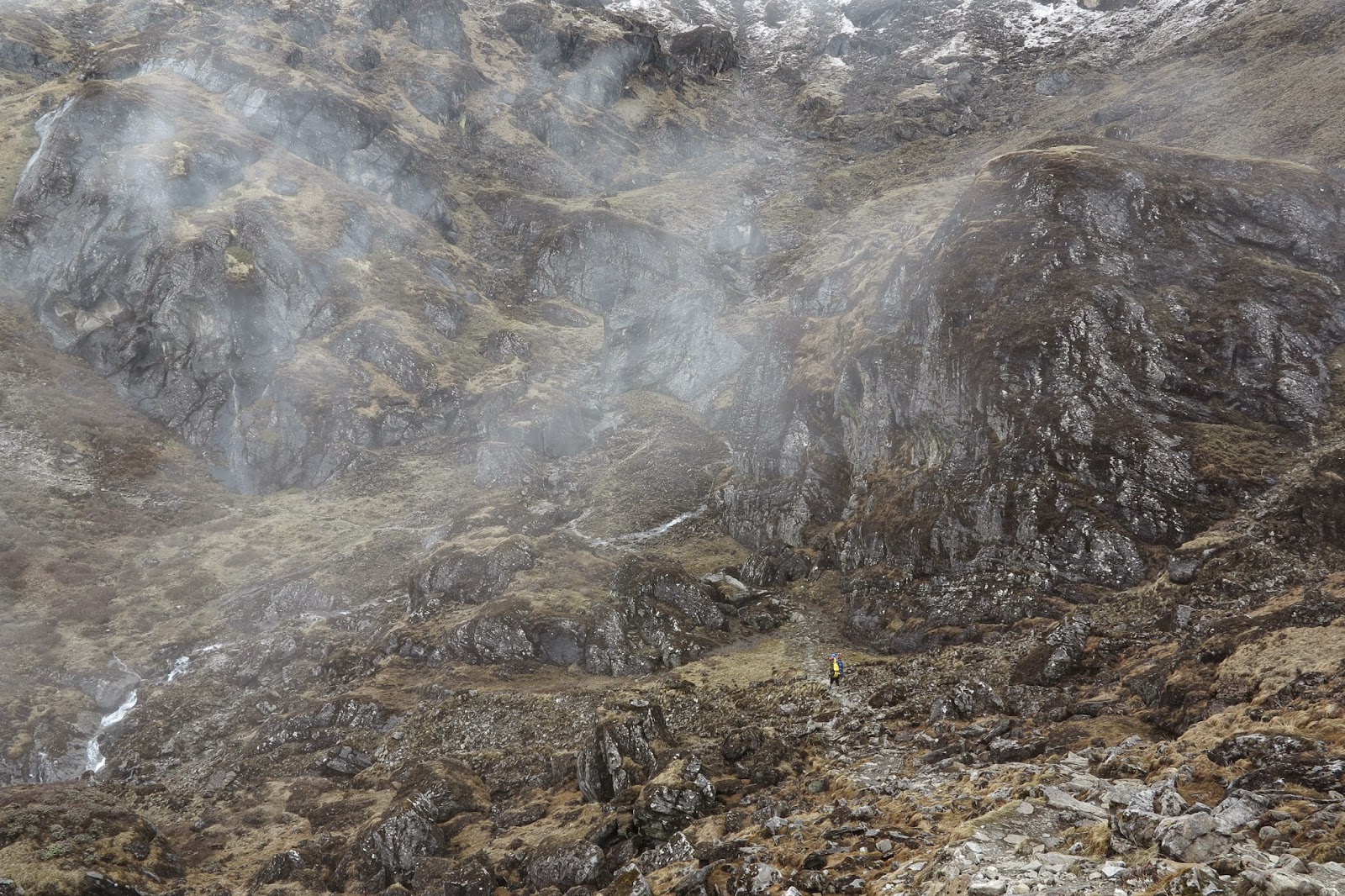
The route to Chetarwa (4600m) consisted a terrain similar to the wet scottish highlands and of course that crazy rocky upslopes and what greeted us were tons of water falls flowing through these routes with them being the only natural pathways for the rain water to flow off the mountains. Though really wet, it was kinda a different experience despite the really irritating rain which caused me to not take much photos. It was like from hopping from stone to stone trying to avoid the streams to just giving up and walking in the water.
With the monsoon moving into the mountain range, sounds of avalanches could be heard in the distant while navigating the high passes and the feeling or relieve that we weren't any were near those places could be felt.
I must say, the weather always sculpted a whole new set of terrain even though it was the same route that we took on the way to the summit. Crossing the high pass that looked so similar to the high pass, the same one where enroute to Kothe a week earlier, was filled with the smell of rosemary was totally different with the slight rain and fog, making it difficult to spot our porter (who amazingly carried 2 of our bags because raj had to leave for another trekking job) who set out front to mark the route as well as to keep track of mr namaste who was quite behind me and whom i didn't want to get lost out there (due to his track record).
Finally, at around 3pm, the small village of Chertawa emerged through the fog and boy was i glad to see it for the growling had started to grow in my stomach for some hot garlic soup. But when upon reaching the village, i was shocked to hear that we might be pushing down to Chutang that day. But that night, we stood round the heater and just chilled, drying our wet socks and shoes at the same time.


Being the last hikers of the season was quite special. The tea houses we passed were mostly packed and ready to evacuate for the monsoon season, waiting for us to pass before packing up completely and heading to Lukla or another village. It was quite funny because the girl that was incharge of the Thangnag tea house followed us to Chertawa and then onto to Lukla followed by Kathmandu. I was always quite shocked when she appeared in the town where we were staying. But her pace was definitely much faster than us. Having left Chertawa an hour ahead of the owner and her, they quickly caught up with us and it was not long before we lost sight of them as they made their advance. It was always rather admirable how these native nepalis adapt so well to their environment while we sea level creatures were dying at that altitude.
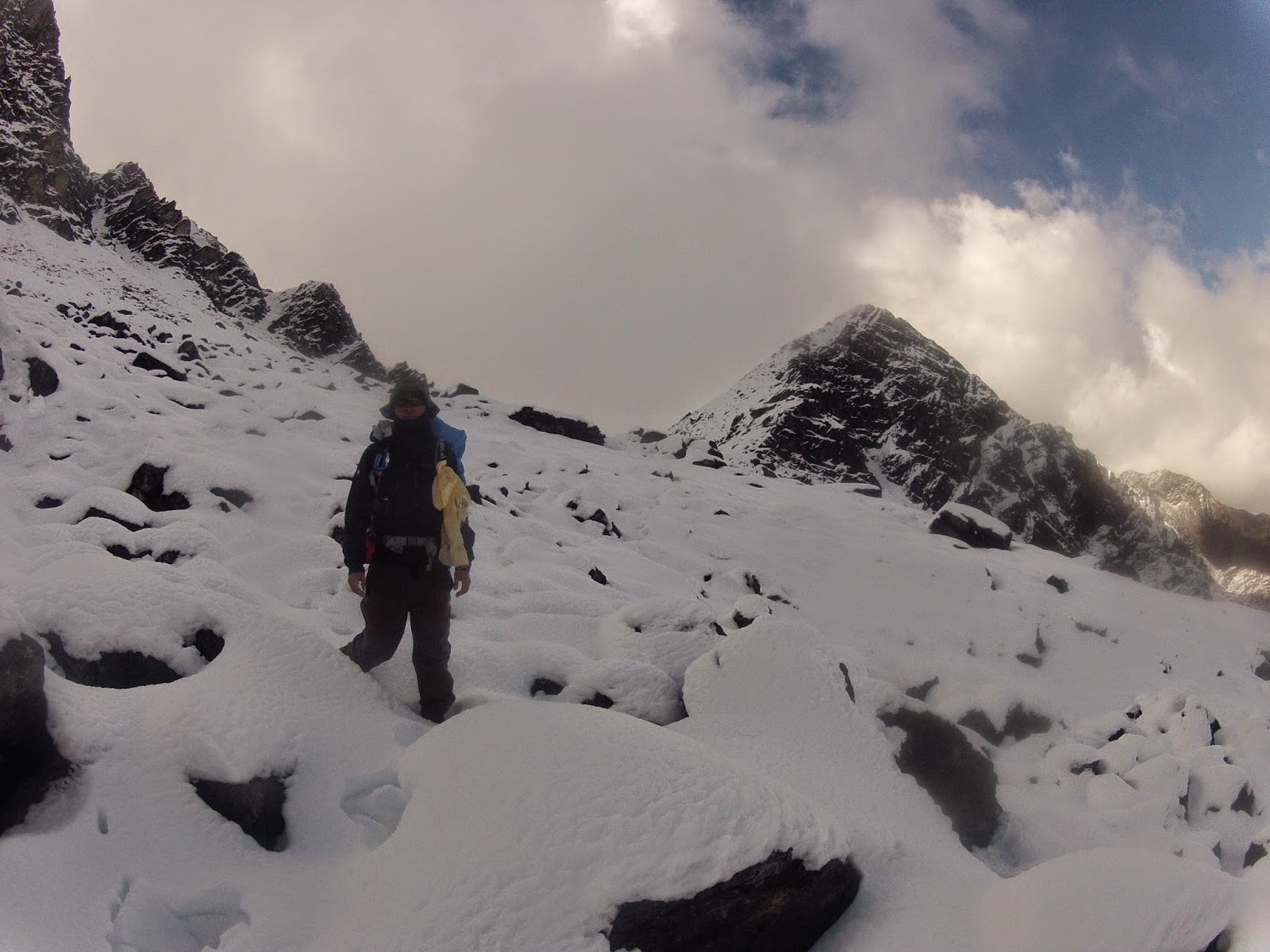
The way back included going through the Thuli Kharka high pass (4800m) and the passage back was so much different than than on the way to the summit. I remembered already dying after reaching the prayer flags at the start of the high pass and there from there on, it was just zombie mode to Chertawa. And the snow made navigating the steep paths easier! Plus it was so much more enjoyable! Possibly the most enjoyable part of my entire trek! Dont know how the locals mark out the route through the heavily snow but at least it didnt involve steep upslope climbs through the thick snow. It traversed through the slopes of the hills and most of the paths were already marked out by deep footprints by the 2 locals who worked at the tea house. All I had to do was just jump into these foot "holes" until it disappeared.
The film that came to mind when traversing this high pass was really the "secret life of walter mitty" It was just amazing walking in between the snow covered hills on the right and the clouds coming through you from the left. The scenery was truly breath taking and perhaps because i was already conditioned to the altitude, the trek felt more enjoyable. This was not expected at all! I left the tea house at chertawa expecting the same route back with the same scenery. But upon reaching the first knoll and staring into the horizon where the route led, i realized that i had to put on my contacts in the middle of no where, to wear my sunglasses because it was going to be snow throughout. And navigating through the snow without a pair of sunglasses would leave you snow dazed and of course, after the painful snowburn effect from the summit descent, i was all wrapped up and ready to go.
It was so much more fun with the snow this time compared to the summit push! Could really afford to play around with the snow! Jumping and running around, trying not to tumble down the steep slopes made the trek seem really short. Though most of the major landmarks were already covered in snow, the prayer flags remained and it was a benchmark of how much the terrain changed over a course of a week.


The route to Chetarwa (4600m) consisted a terrain similar to the wet scottish highlands and of course that crazy rocky upslopes and what greeted us were tons of water falls flowing through these routes with them being the only natural pathways for the rain water to flow off the mountains. Though really wet, it was kinda a different experience despite the really irritating rain which caused me to not take much photos. It was like from hopping from stone to stone trying to avoid the streams to just giving up and walking in the water.
With the monsoon moving into the mountain range, sounds of avalanches could be heard in the distant while navigating the high passes and the feeling or relieve that we weren't any were near those places could be felt.
I must say, the weather always sculpted a whole new set of terrain even though it was the same route that we took on the way to the summit. Crossing the high pass that looked so similar to the high pass, the same one where enroute to Kothe a week earlier, was filled with the smell of rosemary was totally different with the slight rain and fog, making it difficult to spot our porter (who amazingly carried 2 of our bags because raj had to leave for another trekking job) who set out front to mark the route as well as to keep track of mr namaste who was quite behind me and whom i didn't want to get lost out there (due to his track record).
Finally, at around 3pm, the small village of Chertawa emerged through the fog and boy was i glad to see it for the growling had started to grow in my stomach for some hot garlic soup. But when upon reaching the village, i was shocked to hear that we might be pushing down to Chutang that day. But that night, we stood round the heater and just chilled, drying our wet socks and shoes at the same time.
Passing through one of the new waterfalls
Walking pass the many new streams made by the monsoon in the mountains
Avalanches could be heard in the distant mountains
Someone made a welcome sign for us out of flower petals!
Totally giving up on trying to avoid the streams
Frost on his eyebrows as we headed higher in altitude
Trying to keep sight of the porter
Really amazing scenery as the clouds roll across it.
Sighting Chertawa from afar
As KY passes the finally ridge before making it to the base of the village
Night sky in Chertawa
The way back included going through the Thuli Kharka high pass (4800m) and the passage back was so much different than than on the way to the summit. I remembered already dying after reaching the prayer flags at the start of the high pass and there from there on, it was just zombie mode to Chertawa. And the snow made navigating the steep paths easier! Plus it was so much more enjoyable! Possibly the most enjoyable part of my entire trek! Dont know how the locals mark out the route through the heavily snow but at least it didnt involve steep upslope climbs through the thick snow. It traversed through the slopes of the hills and most of the paths were already marked out by deep footprints by the 2 locals who worked at the tea house. All I had to do was just jump into these foot "holes" until it disappeared.
The film that came to mind when traversing this high pass was really the "secret life of walter mitty" It was just amazing walking in between the snow covered hills on the right and the clouds coming through you from the left. The scenery was truly breath taking and perhaps because i was already conditioned to the altitude, the trek felt more enjoyable. This was not expected at all! I left the tea house at chertawa expecting the same route back with the same scenery. But upon reaching the first knoll and staring into the horizon where the route led, i realized that i had to put on my contacts in the middle of no where, to wear my sunglasses because it was going to be snow throughout. And navigating through the snow without a pair of sunglasses would leave you snow dazed and of course, after the painful snowburn effect from the summit descent, i was all wrapped up and ready to go.
It was so much more fun with the snow this time compared to the summit push! Could really afford to play around with the snow! Jumping and running around, trying not to tumble down the steep slopes made the trek seem really short. Though most of the major landmarks were already covered in snow, the prayer flags remained and it was a benchmark of how much the terrain changed over a course of a week.
Starting our route up to the Thuli Kharka High Pass (4800m)
View of Chertawa on the way up!
Starting to see signs of snow
Rest Point!
Slightly over a week earlier at the same spot but overlooking the valley
Being overtaken by the locals who climbed up so quickly!
some snowball fun
snow ninja

traversing through


just like little black spots on the white face of the range
And the route only got easier when we finally started going on our downslope. The snow really made it easier to run/hop downwards and before we knew it the snow started thinning out and we were on the wet stones. But in the distance, we could see the black clouds rolling in and we had to get to the lunch village before the monsoonal rains came in.


How the path looked like when we were going the other way around a week+ earlier


View of the Chutang

Shag face of KY upon reaching the lunch village of Chutang!

Little kids of Chutang
At last, with a little energy gained through our stomachs, we made the final push back to Lukla and the next day we left it for Kathmandu through the most dangerous airport in the world. (and perhaps a dangerous airline too. one of the passenger windows expended rapidly that i thought it would pop out and hit the propellor). The feeling of reaching back to civilization was overwhelming. It would be the first time we could shower after 2 weeks, a proper bed, more food choices and of course, being connected to the world! And to top it all, that was the night i checked my results and to the namaste experience up with a cherry, I found out i finally made it out of university with first class honors!
The expedition definitely took a toll on my body. I lost an incredible amount of mass and it could really be felt when i finally took my shower after the trip, as if i was scrubbing bones. Kind of sucky feeling especially when i neeed those mass and strength for my bouldering trip in France. But it was definitely an experience that i would remember for life! The scenery, hardship, friends and the experience would be ingrained into my mind forever. Though there were many times that i felt like giving up because of the altitude + terrain, i'm glad i had the fortitude and endurance to push through despite what my mind kept telling me to give up and most of all, stayed safe without any incidents.
And with that i would also like to thank Peace Nepal Treks. You can find more info about the company "here"

Finally an accom that doesnt require us to sleep in sleeping bags!

Taking a pic of the range that we passed earlier that day. we could even see the prayer flags from down there

Plane taking off from the world's dangerous airport.

After a 3 hour wait at the airport since 7am, we were finally out of there, a different person, moulded by the mountains.


